



- Shear-hosted gold discovery at the Bella Prospect – LAMRC015 returned 24m @ 1.66 g/t Au from 54m, including 7m @ 1.79 g/t Au (54–61m) and 6m @ 2.9 g/t Au (72–78m, end of RC drilling)
- Secondary sub-vertical quartz vein intercepts near surface (Estimated True Width 1-2m): 11m @ 4.5 g/t Au (27–38m, incl. 1m @ 19 g/t Au) and 6m @ 1.8 g/t Au (8–14m)
- Diamond tail LAMDT015 logged visual mineralisation from 78m to 95.8m (end of hole); visual mineralisation is open at depth.
- Shear-zone mineralisation interpreted as a near-surface, tabular structure dipping ~30° south within schist foliation; open to the west, to the south and at depth
- LAMRC015 was drilled 92m west of LAMRC013, the best hole from the 2025 maiden program (6m @ 0.65 g/t Au)
- Phase 2 drilling complete: 1,053.7m (907m RC and 146m diamond core); cumulative Lammerlaw drilling now 1,511.7m
- ‘Camp scale’ potential – the Lammerlaw Mineral Trend (LMT) defined is a highly prospective tectonic-stratigraphic package up to 100m thick extending more than 5km along strike within the permit, illustrating the potential for multi-million ounce gold discovery
Overview
The Lammerlaw Gold-Antimony Project (Exploration Permit EP60807, 74.8 km²) sits within the Otago Schist Belt of New Zealand, a well-endowed orogenic gold province that hosts the Macraes Gold Mine. NAE holds a 100% interest.
Mineralisation at Lammerlaw is interpreted to be associated with shear-hosted quartz veining and structurally controlled fluid flow along the southern limb of the Otago antiform, the geological “mirror image” of the Hyde-Macraes Shear Zone on the northern limb (MacKenzie and Craw, 2016). The permit contains analogous rock types, including pelitic and psammitic schist in textural zone 3 of the Otago Schist belt, and has a history of alluvial mining alongside shallow hard-rock workings dating mostly from the late 1800s.
Much of the permit is blanketed by 1–5m of loess (windblown silt) over weathered schist, which conceals mineralisation from conventional surface sampling. The target lithogoly is carbonaceous peilitic schist, which outcrops poorly which has further concealed mineralisation from historic miners and from modern day conventional surface sampling. NAE’s exploration approach has combined hand-auger soil sampling through the loess, rock-chip geochemistry, regional electromagnetics and the mapping of historic workings from 1870s–90s aerial photography, defining mineralised trends of up to 8km across the permit.
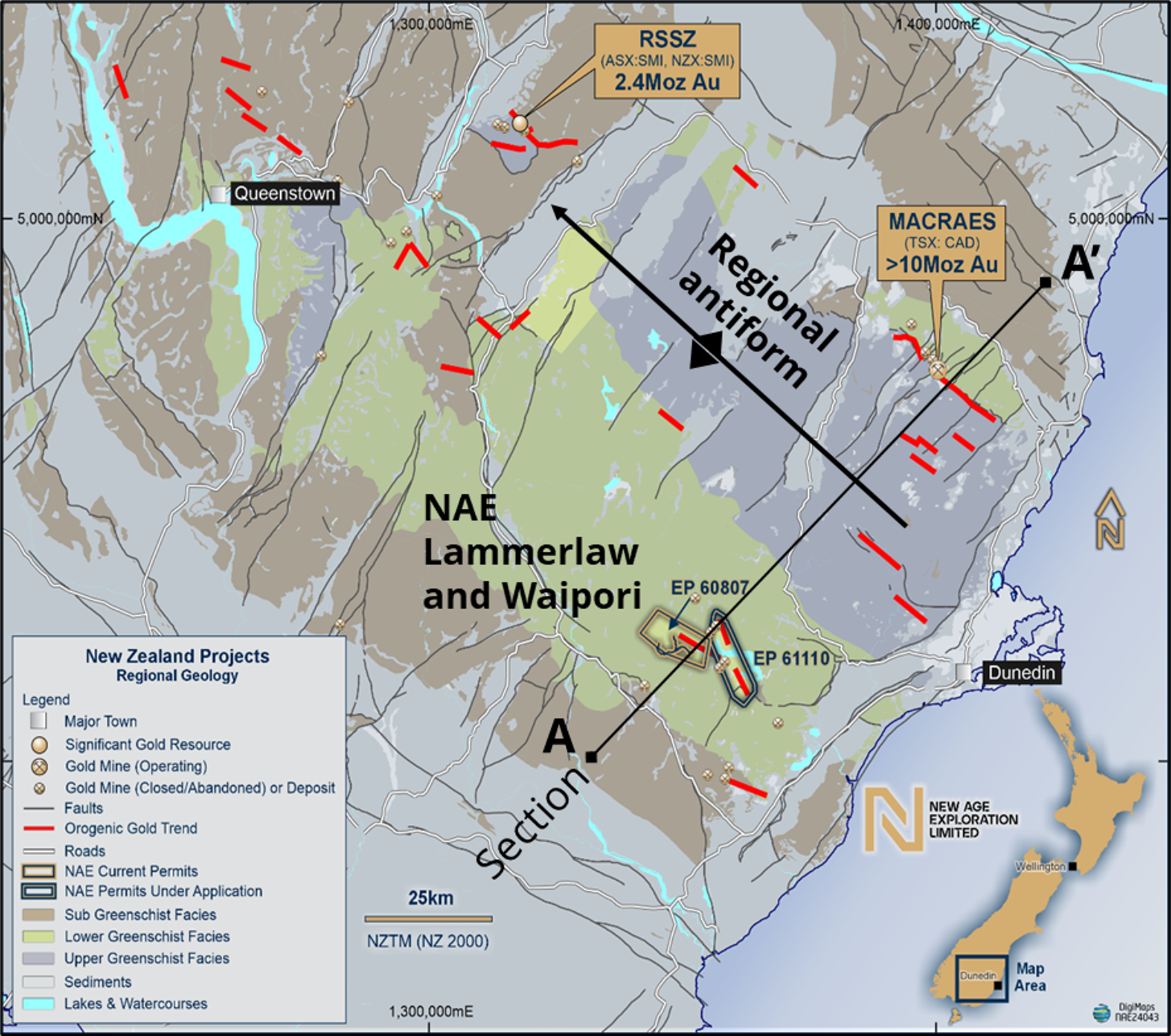
Figure 1 – The NAE Otago project – Lammerlaw (EP60807) and Waipori (EP61110) exploration permits within the Otago Schist Belt of New Zealand.
Bella Prospect – A New Shear-Hosted Discovery
In June 2026 NAE reported assays from RC hole LAMRC015 and its diamond core tail LAMDT015 at the Bella Prospect. The hole intersected substantial shear-hosted gold mineralisation, representing a new technical discovery at the project.
Prior to LAMRC015, exploration at Lammerlaw had focused on the steeply dipping quartz vein systems worked by historic miners. LAMRC015 intersected both styles, the sub-vertical veins and a new, separate, shallow-dipping tabular shear zone hosted within the schist foliation. It is the shear-hosted style, distinct from the vein systems previously understood to characterise the trend, that is analogous to the Macraes system.
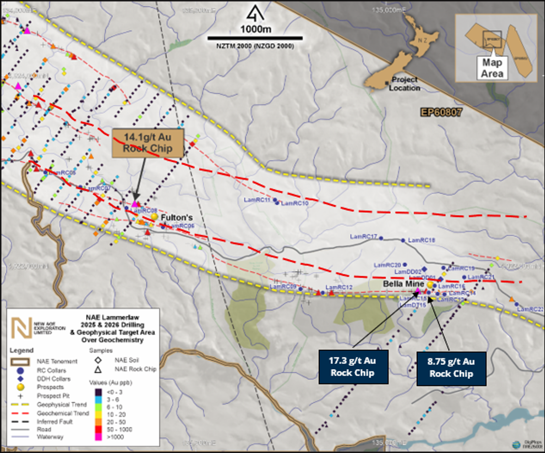
Figure 2 – Location of the Bella Prospect within the Lammerlaw Mineral Trend, Otago Region, New Zealand – 2025 and 2026 drill collars over gold geochemistry, showing 17.3 g/t Au and 8.75 g/t Au rock chip results.
LAMRC015 — significant intercepts
| Interval | Grade | Style |
| 8–14m (6m) | 1.8 g/t Au | Sub-vertical quartz vein |
| 27–38m (11m) | 4.5 g/t Au, incl. 1m @ 19 g/t Au | Sub-vertical quartz vein |
| 54–61m (7m) | 1.79 g/t Au | Shear zone |
| 72–78m (6m) | 2.9 g/t Au | Shear zone (end of RC drilling) |
| 54–78m (24m) | 1.66 g/t Au | Shear-hosted gold mineralisation |
| 78-95.8 (17.8m) | Assays pending (expected Q2 2026) | Shear-hosted gold mineralisation. Note: visual mineralisation is open at depth |
Significant intercepts are reported at a 0.50 ppm Au lower cut-off; the 24m @ 1.66 g/t Au interval is reported at a 0.1 ppm Au cut-off to demonstrate the width of the mineralised system. All intercepts are downhole widths.
LAMRC015 was drilled at approximately –70°. The dip of the tabular shear zone (~30° south) is constrained by multiple foliation measurements in surrounding outcrop, and true width is expected to approach the reported intercept length. The sub-vertical veins are estimated at 1–2m true width and, being near-surface and partially weathered, their high grades are interpreted to be in part the result of secondary enrichment.
LAMDT015 – diamond tail
A diamond core tail was drilled from 78m to 95.8m (end of hole), capturing 17.8m of the shear-hosted zone with excellent core recovery (>95%). Disseminated sulphides and quartz veining consistent with the shear-hosted system were logged throughout the core and continue to the bottom of the hole. The thickness of the zone is therefore open at depth. Visual observations support continuity but do not confirm grade; assays are pending.
Bella Mine context
The historic Bella Mine lies approximately 120m west of the LAMRC015 collar, along strike. The site contains surface workings and old shafts to roughly 15m depth dating from the late 1800s, with historic assay grades of 15.1 g/t gold. Historic mining focused on the high-grade sub-vertical quartz veins; shear-hosted mineralisation, if present, was likely too deep for the mining methods of the day. NAE intends drilling deeper below the Bella Mine to test for lateral extension of the shear-hosted gold mineralisation encountered in LAMRC015-LAMDT015.
The Lammerlaw Mineral Trend
Phase 2 drilling, combined with regional electromagnetic surveys, soil sampling, rock-chip geochemistry and interpretation of abundant historic workings (alluvial pits, trenches, shafts and underground adits), has allowed NAE to define the Lammerlaw Mineral Trend (LMT): a prospective tectonic-stratigraphic package interpreted to be up to 100m thick, extending more than 5km along strike within the permit and hosting gold, antimony, tungsten and associated mineralisation.
Four principal prospects sit along the trend, each with a legacy of historic mining and exploration:
| Prospect | Historic context | NAE work to date |
| Bella | Lode discovered 1890s, worked to 1900; E–W striking, steeply dipping, historic grades ~15 g/t Au | Focus of Phase 2 drilling; site of the LAMRC015 shear-hosted gold discovery |
| Fulton’s | Group of quartz vein occurrences in an area extensively worked for alluvial gold and tungsten | Gold-arsenic geochemical trend defined over ~3.4km; 14.1 g/t Au rock chip |
| Bucks | No historical documentation; indicated on historic maps ~1.9km arsenic-gold geochemical trend defined by auger and rock-chip sampling | ~1.9km arsenic-gold geochemical trend defined by auger and rock-chip sampling |
| Antimony Mine | Discovered in Stony Creek late 1870s, mined intermittently 1880–1900 for stibnite-rich ore Geochemical trend extended to roughly 3.5km; 27.0 g/t Au float | Geochemical trend extended to roughly 3.5km; 27.0 g/t Au float |
Phase 2 Drilling Program
Phase 2 commenced in March 2026 and was completed in June 2026. The program was designed to test the along-strike and down-dip continuity of the mineralisation intersected in Phase 1, and to improve understanding of the broader structural controls on gold and antimony mineralisation.
| Total drilled | 1,053.7m |
| RC | 907m |
| Diamond core | 146.7m (two core holes targeting the zone around LAMRC013) |
| Cumulative Lammerlaw program | 1,511.7m (Phase 1 and Phase 2) |
| Status | Complete; all samples submitted for assay |
Refer to ASX Announcements dated 18 March 2026 and 15 June 2026.
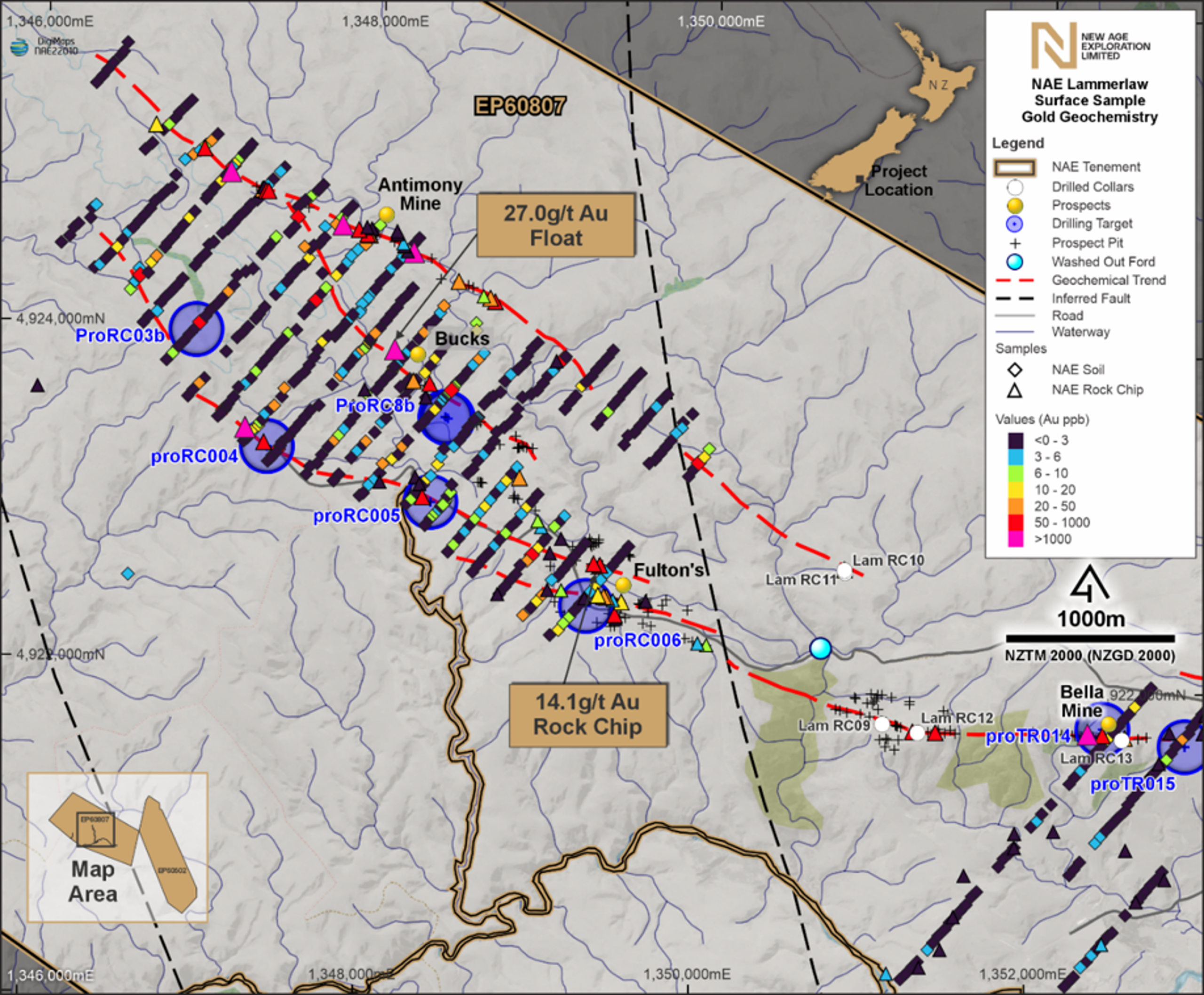
Figure 3 – Location of Lammerlaw Phase 2 holes overlaid on gold values from soil samples.
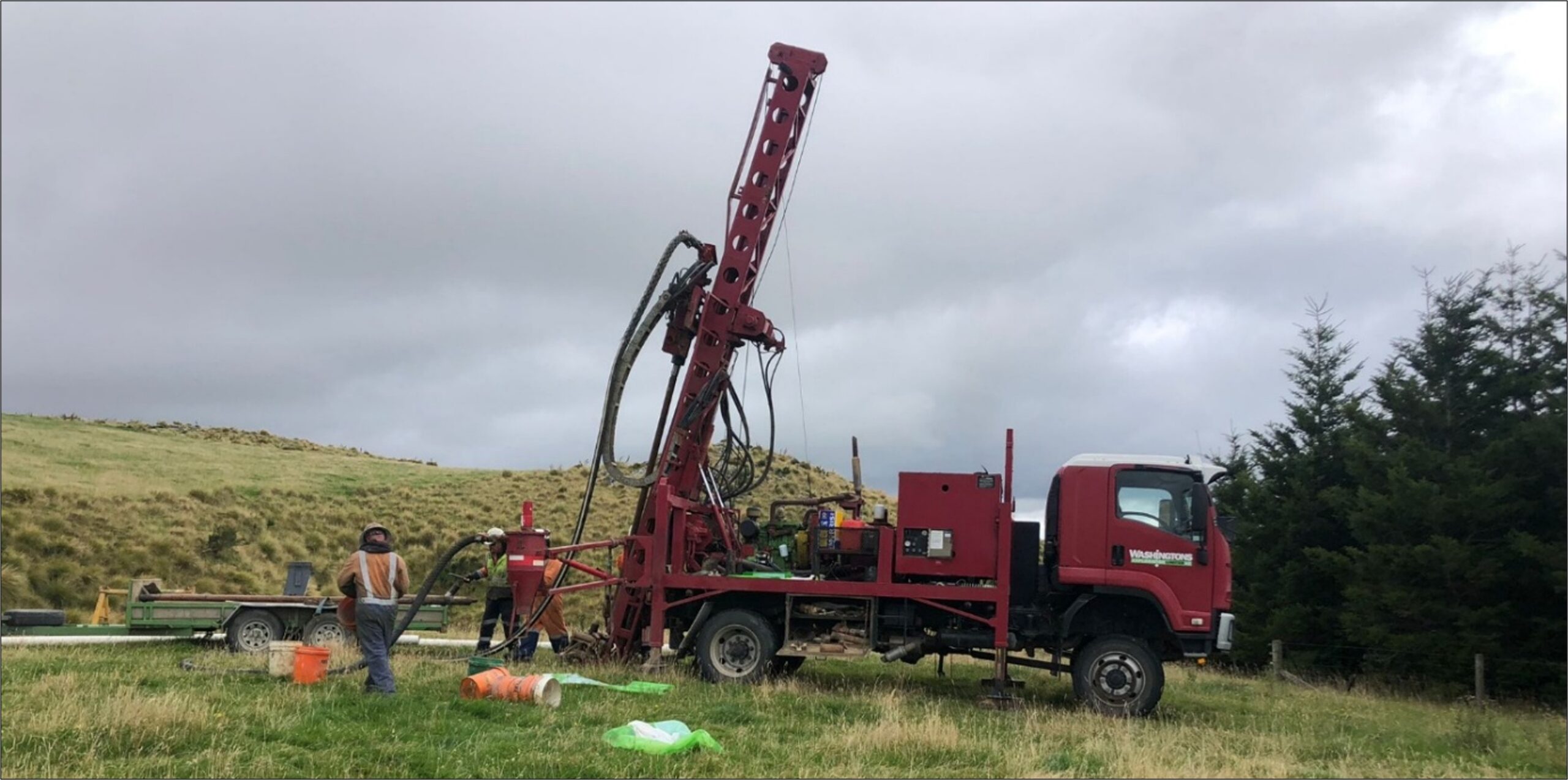
Figure 4 – Drilling rig on site at Lammerlaw (March 2026)
The Macraes Analogue
The Otago Schist belt is divided into structural blocks of increasing metamorphic grade. Gold mineralisation at the Macraes deposits, hosted in the Hyde-Macraes Shear Zone, occurs entirely within the Lower Greenschist Facies zone in the northeast of the belt.
MacKenzie and Craw (2016) identified the potential for Macraes-style shear-zone-hosted gold to occur in the southern part of the Otago Schist belt, within the Lower Greenschist Facies zone that includes NAE’s Lammerlaw permit. The tabular geometry, pelitic schist host and pathfinder geochemistry observed at the Bella Prospect are consistent with that model.
For context, the Macraes Mine (operated by OceanaGold, TSX: OGC) commenced production in 1990 and has produced over 6 million ounces of gold across a continuous 35-year operating history, with remaining measured and indicated resources of 54.8 Mt @ 0.85 g/t for 1.49 Moz Au.
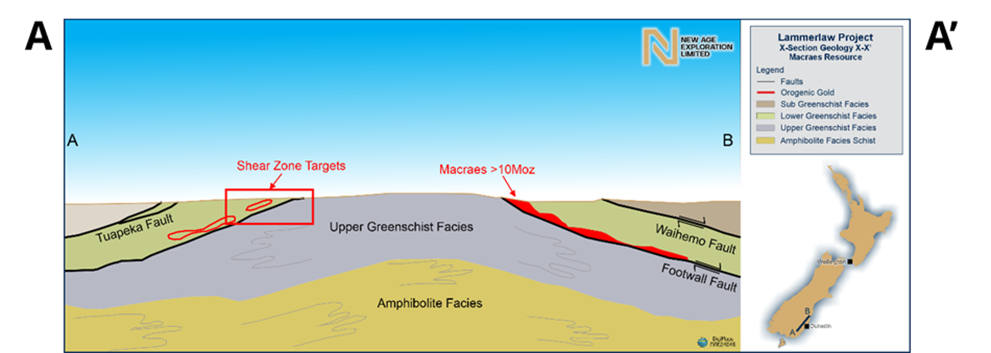
Figure 5 – Schematic diagram showing proposed antiform and southern limb targets.
Cautionary statement: References to the Macraes gold deposit are provided for geological context only, to explain the style of mineralisation targeted at the Lammerlaw Project. This does not imply that Lammerlaw will host a deposit of similar size, grade or economic potential. The Lammerlaw Project is at an early stage of exploration, and no Mineral Resource or Ore Reserve has been defined.
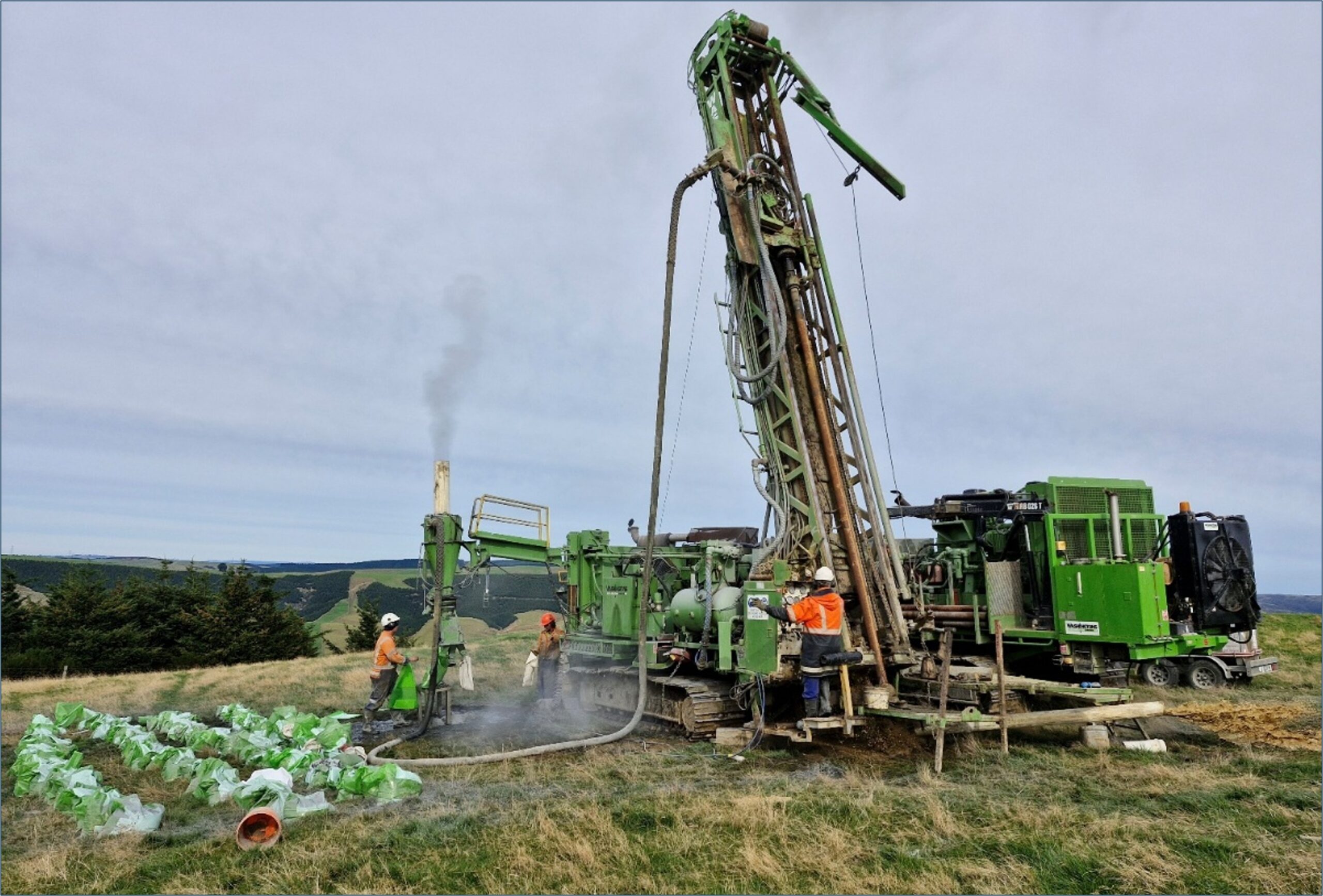
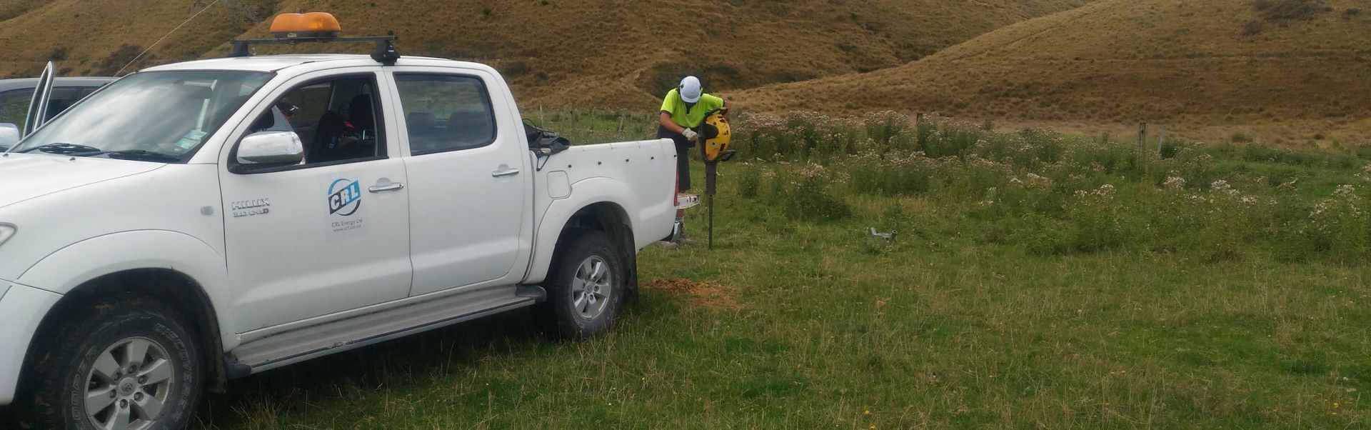
Figure 6 – Photo of RC drilling operation on Waipori Station, 2025 drilling program, Lammerlaw.
Key ASX Announcements
View all ASX Announcements
Competent Person’s Statement
The information on this page that relates to Exploration Results in New Zealand is based on information compiled and reviewed by Mr Kerry Gordon, who is an exploration geologist and a Member of the Australasian Institute of Mining and Metallurgy. Mr Gordon has sufficient experience relevant to the styles of mineralisation and type of deposit under consideration and to the activity being undertaken to qualify as a Competent Person as defined in the December 2012 Edition of the “Australasian Code for Reporting of Exploration Results, Mineral Resources and Ore Reserves”. Mr Gordon consents to the inclusion of the matters based on his information in the form and context in which it appears.
Previously Reported Results
Where this page references previously reported exploration results, the Company confirms that it is not aware of any new information or data that materially affects the information included in those announcements. All material assumptions and technical parameters underpinning the relevant estimates continue to apply and have not materially changed.
Forward-Looking Statements
This page contains forward-looking information based on the Company’s expectations, estimates and forecasts as at the date the statements were made, including statements regarding the timing and completion of drilling, sampling and assay activities. Forward-looking information is not factual and represents only expectations, estimates and forecasts about the future. It should be read bearing in mind the risks and uncertainties concerning future events generally.
References
MacKenzie, D.J. and Craw, D. 2016. Structural and geophysical domains in the southwestern side of the Otago Schist belt, New Zealand. Proceedings of the 49th Annual Conference, New Zealand Branch, AusIMM: 223–232.
Mackenzie, D., Craw, D. and Fietz, G. 2017. Exploring for gold-bearing shear zones on the southwestern side of the Otago Schist belt, New Zealand. AusIMM NZ Branch Annual Conference, Christchurch.
Marshall, P. 1918. The Geology of the Tuapeka District, Central Otago Division. Department of Mines, Geological Survey Branch.