

- Additional high-grade gold prospects identified from recent field work
- Coarse visible gold found in float samples close to historic workings
- Target lengths significantly extended to >6km along the highly prospective OPQ fault zone, capable of hosting significant gold deposits
- Re-processed geophysics identified new targeting methodology for structures hosting high-grade gold lodes
- Several prospects within the OPQ Gold Project area now have high priority drill ready previously untested targets
Overview
The Central Otago Schist Belt is renowned for the famous Otago gold rush that began in the 1860s, when alluvial gold was discovered in extremely rich Gabriel’s Gully, an area located less than 15km to the east of OPQ Gold Exploration Project. Hard rock gold mining followed but stopped in the early 1900s. Since then, very little focused modern exploration has been applied and no drill has ever been completed within the OPQ Gold Exploration Project area. This combination of historically productive ground in an under-explored area presents an exciting opportunity for NAE to make a significant discovery.
Anomalous Arsenic and Visible Gold
Ongoing field activity in OPQ Gold Exploration Project has accurately located numerous historic mines and prospects hosting high-grade gold mineralisation. Review of historic aerial photography was used to locate surface prospecting pits and shafts dug from the 1860. Some locations have not been visited or sampled in the past 120 years.
Recent samples collected from quartz lodes and geochemical trends were tested with pXRF and recorded highly anomalous arsenic, antimony, and tungsten geochemistry – all common pathfinder elements associated with gold mineralisation. Field work has greatly extended target lengths to scales capable of hosting significant gold deposits.
Visible gold was noted in float samples found close to old workings. Quartz veins have a laminar, multi-phase appearance and can contain rhombic arsenopyrite and free gold. Historic records indicate mined quartz lodes typically had grades of ~15g/t Au. This does not include gold contained within sulphide that could not be recovered at the time.
Geological structures hosting gold in the OPQ Gold Exploration Project contain both mineralised fault breccia and high-grade quartz veins. There is currently no modern information on the potential grade of mineralised fault breccia hosting quartz veins, representing a significant up-side for the OPQ Gold Exploration Project.
Re-processed geophysics and recently collected field data has greatly increased the geological understanding of gold mineralisation within the OPQ Gold Exploration Project area, resulting in exciting new exploration targets that are yet to be field checked (Figure 1).
Rich History of Historic Mining
Refined desk-top and field work has greatly improved the understanding of prospects within the OPQ Gold Exploration Project. There are now ten or more prospects progressing towards a drill ready status, with additional prospects requiring further test work (Figure 2). NAE is now confidently advancing towards drill testing the highest-ranking targets.

Figure 1: Overview of prospects locations within the OPQ Gold Exploration Project.

Figure 2: Detailed view of the OPQ Group of prospects. Note the small arsenic footprint that highlights the OPQ Mine area.
OPQ Fault Zone
The OPQ group of mines and prospects sit along, or parallel to, the OPQ Fault Zone which trends NW through the OPQ Gold Exploration Project (Figure 1). NW trending structures host both the Macraes and Bendigo-Ophir orogenic gold deposits. The OPQ Fault Zone has a mapped and inferred length >6km and represents a significant opportunity for discovery. Recent advances in understanding of historic mining, including location of old mine plans, have upgraded the OPQ Mine, OPQ Victory and Burtenshaws Prospect to drill ready targets. Access negotiation are to proceed towards drill testing these targets in the next phase of exploration.
The OPQ Mine was the largest and most productive hard rock gold mine in the area. Recent 3D modelling of old OPQ Mine plans demonstrates a known mined strike length of 480m and was developed to a vertical depth of 45m, across three levels.
Mined gold grades were extremely rich at surface, averaging 15g/t at depth, typically from a single quartz vein varying width up to a maximum of 3m. Quartz veining was intermittent along strike, but consistently sits within 3-6m of mineralised fault breccia – the OPQ Fault Zone (Marshall, 1918 and Rickard 1875). Historic mining focused entirely on high-grade lenses of quartz, from which free gold could easily be recovered. Drill testing the OPQ Mine now represents a significant opportunity for NAE to test a large structurally hosted target.
South of the OPQ Mine at OPQ Victory, the OPQ Fault Zone is masked by shallow swampy cover (6-15m deep). NAE sampling through this cover has demonstrated mineralisation may extend for 2.8km to the OPQ South Prospect (Figure 2). NAE now considers this area an outstanding opportunity for new discovery under shallow cover.
On the north side of Lake Mahinerangi at Burtenshaws Prospect mined a narrow slot of alluvium that was once the course of an ancient river (Figure 3). At the base of rich alluvial workings, outcropping mineralisation was uncovered (Rickard, 1875). Similar geological situations are common in the Victorian Goldfield, Australia where deep leads often sit above hard rock gold mines.
The alluvial slot at Burtenshaws Prospect (now filled with water) lines up perfectly with OPQ Mine working on the opposite side (south) of Lake Mahinerangi. The Burtenshaws Prospect represents a 600m long, highly prospective conceptual drill target, where historic records and NAE’s recent sampling in the area provide confidence that the OPQ Fault Zones continue north of Lake Mahinerangi.
Additional prospects associated with the OPQ Fault Zone include Canton Mine and OPQ South. These prospects are currently considered second phase drill targets.
High-Grade Narrow Vein Prospects
Recent systematic exploration by NAE has located historic prospects and mines on the north side of Lake Mahinerangi for the first time. No previous geochemical sampling has been completed along some of these highly prospective trends.
The ABC and Nuggety Gully prospects are located on a semi-continuous geochemical trend marked by alluvial and hard rock workings traceable for roughly 2km in a NW direction from the northern shore of Lake Mahinerangi (Figure 3). ABC has shallow surface workings over a 250m strike that produced rich specimen gold.
Nuggety Gully is associated with 850m long alluvial working. Historic hard rock mining from one level 180m long with a historic test crush averaging 10.25g/t Au. Recent work found visible gold bearing float close to mine workings. The high-grade potential and significant strike length potential of Nuggety Gully make it a worthy target for further testing. Trenching across the ABC and Nuggety Gully trend is a likely next progression towards drill readiness.
The Cox’s and Cosmopolitan Prospects are located in the northern part of the OPQ Gold Exploration Project (Figure 4). Quartz was worked from two steeply dipping shoots at Cox’s. These shoots were narrow but contained up to 60g/t Au. Large quantities of specimen gold were obtained when first worked, with workings extending off three levels, with quartz still showing at foot along the lowest level (Marshall, 1918). During a recent visit to the Cox’s, a piece of quartz float found in a field ~20m south of now ploughed in historic prospecting pits contained disseminated visible gold and arsenopyrite/scorodite.
The Cosmopolitan group of lodes is located ~1km south of Cox’s. Historic records are sparse but suggest there were two or three sub-parallel reef lines worked. No production is recorded, historic test work indicate quartz contained 15g/t Au. Recent field work at Cosmopolitan found old prospecting pits could be traced over a ~800m strike length. Most of these old workings had been ploughed into fields, but where exposed, sulphide seamed quartz could be sampled.

Figure 3: Detailed view of the ABC and Nuggety Gully Prospects. Sandaggers and Burtenshaws Prospects sit along the northern continuation of the OPQ Fault Zone.
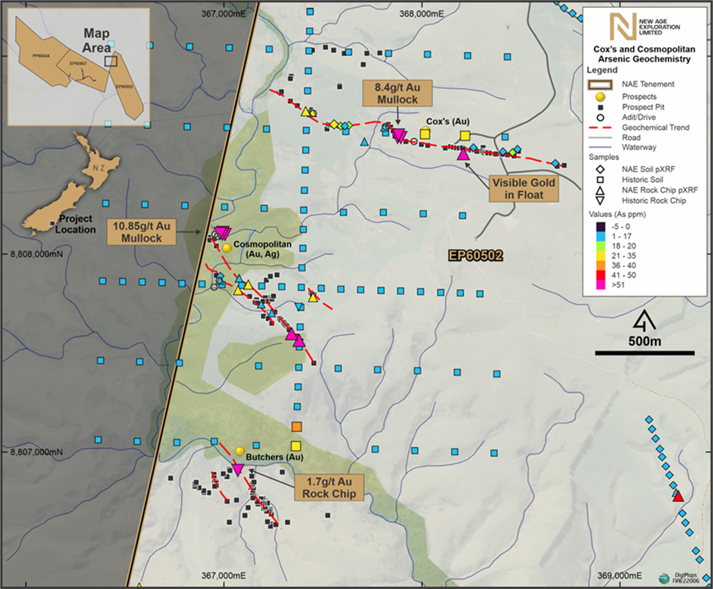
Figure 4: Cox’s and Cosmopolitan Prospects in the northern part of the Mahinerangi Permit.
References:
- Marshall, p. 1918: The geology of the Tuapeka District, Central Otago Division. Department of Mines Geological Survey Branch. Bulletin 19.
- Rickard 1875. “The Goldfields of Otago”, in Trans. Amer. Inst. Min. Eng., vol. xxi, 1983, p.411


